Sunday, 28 July 2024

The Street that became longer...

When I was a child we would often travel to visit family North of the River and our primary route over the river from Peckham was over Tower Bridge.

Apparently my mother said that her Grandmother was one of the first to cross the river when it opened …. well as a twenty one year old when it opened that makes perfect sense…


Anyway I remember looking out of the window and seeing an odd named street Shorter Street

And it was short; one building – and not even a big one.

Looking at old Ordinance Survey Maps and lining them up with Google the distance would seem too be no more than 20m.


Now that is short and it was even then no more than the length of a traffic island which is what it virtually was … 

However when you check out old maps you can see that a section of Royal Mint Street became isolated when they built Mansell Street across it to improve access to Tower Bridge and on later OS maps after it was built the old section of Royal Mint Street is unnamed.
 

Today Shorter Street's name has been attached to that “unnamed length of road and is over 90m long while the site of the “original” street I knew is now part of the widened Tower Hill carriageway, little more than a bit of carriageway crossing of Tower Hill for buses

Friday, 2 January 2015

The Death of Walter Smith 1919 Woolwich

As I say on the video  many years ago I recorded my Grandfather and his Elder sister and over the last few years I have selected a few short sections of the audio to upload as a record. 

This is a section describing the death of my Great Great Uncle Walter in Woolwich, South London, tragically within months of having survived the First World War. 

Saturday, 3 August 2013

Brixton Mills


I have to admit that when I was younger, even though I lived in Peckham only a few miles away, I'd never heard of Brixton mill, and by that I mean the windmill and not the other one (of which later).

In fact even when I started to research this article I still hasn't seen it!* (despite going to Brixton College round the corner in the 1970s)

Yet the mill was a local landmark having been about a long time. Not far away is another famous (or infamous) landmark, Brixton prison, built around the same time it is London's Oldest Prison.

It was in fact hearing a radio programme with that name, about the prison, which drew me to writing about these neighbours, for such they are, and is not just location that connects them...


Of course when Ashby's Mill was built in 1816 Brixton looked very different surrounded by fields to supply its raw material. It looks an idyll in the picture on the left.

A few years later, around 1820, a prison was built nearby, the Surrey House of Correction, and they have been neighbours ever since. It was intended to house 175 prisoners, but regularly exceeded that with 200 prisoners making overcrowding an early problem. Combined with its small cells and poor living conditions it soon had a reputation as one of the worst prisons in London.

The Windmill worked until 1862 when a watermill at Mitcham succeeded it, during that time it suffered competition, because for as well as the Watermill(s) in Mitcham there was a wholly different sort of mill on its doorstep; a Treadmill.


Invented in 1818 by William Cubitt the treadmill was installed into Brixton Prison in 1821 and was the main implement of punishment in the days of hard labour, driving millstones grinding flour for the prison bakery. The prisoners would tread for 20 minutes then rest for 5 minutes then repeat for up to 12 hours or during daylight whichever was shorter and for 6 days a week.

The Windmill got new sails in 1821 called spring sails they now
didn't need cloth to be spread as these sails use shuttered wood (also invented by Mr Cubitt); but even these were removed in when the windmill was relegated to use as a store, which it remained until 1902 when the lease on the watermill expired. The mill was then pressed back into use, but driven by engine, which continued until 1934 supplying wholemeal flour to West End hotels and restaurants.

After the war, there were proposals to demolish the mill and build a block of flats. The proposal was rejected and it was decided to conserve the mill, which was restored in 1964 by London County Council. New sails were fitted, and machinery from a derelict windmill at Burgh le Marsh, Lincolnshire installed to replace that which had been removed, the work being done by Thompson's, the Alford millwrights.


Today? Well once restored the mill was opened to the public in 1968 and three years later
passed to Lambeth Council There have been several restorations since with the most recent being completed in 2011.

Meanwhile in the prison? Well Brixton made the treadmill famous and, within two decades, half the prisons in the country would have one. Then in 1852, overcrowded and with a reputation for brutality, Brixton was closed as a local prison for the south of London. Its notorious treadwheels were dismantled and the land and buildings sold at auction.

Except, at the eleventh hour the government made a compulsory purchase of Brixton and converted it into a prison solely for female convicts (the first of the  kind in the country). This had become necessary as the end of transportation to Australia in the 1850s meant Britain suddenly had to find prison accommodation for thousands of serious offenders. But the history of the prison in detail is a whole other story including its use as a military and remand prisons, All of which you can read here.

Well times move on and in 2012 as part of a television documentary the Bad Boy's Bakery in the prison was set up which supplied coffee shops across London with products made with flour! (Though I see today 2017 - the website has gone so I don't know if it still does)

Ironically the building where this happened is where once the Treadmill's mill stones ground flour!.

Laurie Smith

*Though of course I have during the writing to give you the picture above. 

Wednesday, 28 December 2011

Bombsites and Prefabs

When I was a child in the sixties all the adults were always mentioning the War. The War this, the War that. “In the War ….” It was a normal topic on conversation. To us, as kids, it had a mythic status though being over long before we were born. As I grew into a teenager it seemed odd that they were still so driven by it.

As a man in my fifties looking back I begin to understand. When I do the maths the child I'm recalling must have been no more than eight which means the War had actually been over only twenty odd years and things like rationing and national service much less.
Twenty odd years to the teenager still would seem to be a lifetime but twenty odd years later I look back at events from my teenage and early twenties and they seem like yesterday – and that didn't involve being bombed and losing my home nor the streets being filled with servicemen who may be off to battle tomorrow some never to return.

This blog is not about those people however, nor the War itself, but I have other memories about my youth which have echos from that time. In the early Sixties we still had bombsites to remind those adults about the war. Small parcels of land in the middle or end of a terrace boarded up and where emergency work had been done to clear the damaged buildings and weatherproof the ends of the remaining parts of the terrace with cement. Often used as dumping grounds (as such land often is) they were strewn with broken radios and fridges and the like. Kids liked the radios as the transformer cores could be broken into their laminates and they then got loads of steel “E”s which could be flicked like playing cards, as an adult I dread to think of the damage that they could have done if they'd hit someone in the eye, luckily the kids only used them to play up the wall.

Some of the old bombsites had been used to build “prefabs” however. These temporary prefa
bricated houses were the major part of the plan envisaged to address the post–War housing shortage. They had a planned life of up to 10 years and through use of the wartime production facilities and creation of common standards developed by the Ministry of Works, the programme got off to a good start, but more expensive to build than conventional houses, and of course only being temporary, in the end, of 1.2 million new houses built from 1945 to 1951 only 156,623 prefab houses were constructed.

The ones I knew were on these cleared bombsite in terraces, a couple here an odd one there,
most have now been replaced by modern houses and few survive, though that they lasted into the seventies in many cases is itself a testament to the durability of a series of housing designs and construction methods only envisaged to last 10 years.

Once a common sight in inner south London they now have to be sought out and soon you will probably have to go to a museum. The last ones I know in south London, which I used to see on my way home from work, are on a back street in East Dulwich. So the other day I set off to see if they were still there. Well a couple were, but I'm sure there were more a few years ago, and next door a new block of flats, so even here it looks like they have been reduced in number. In the pictures above and alongside you can see the remaining ones I know and the wall of the house next door rendered to protect was originally built as an internal wall.

In Catford a whole estate has gone following a long battle which you can read about here. I've also linked to the film from youtube as it shows very well the types of buildings which were once a common sight on street corners in ones and twos and now are only memories.

Laurie

Thursday, 14 July 2011

Fences and Flats

Near to where I went to school, both primary and secondary schools, and in fact across a lot of London stand blocks of flats built from the beginning of the 20th century, up until the Second World War. They come in many variations around the same idea, some in London Stock with Red Brick edging, some unusually in a Brown Brick. Most have white highlights on the balconies etc. They have stairs, which are sheltered but open, are often built around a courtyard, commonly have four floors above the ground level, (restricted by having no lifts of course) and, (this being the mysterious bit to me when I was a kid), have grass areas surrounding them with odd bulges and an odd design in fencing.

How odd is the design? Well the pavement boundaries are a low wall often topped with a glazed or polished brick, out of which sprang black metal uprights in pairs every 6-7 feet, fixed to these were horizontal poles which ran along and supported meshwork filling the gaps and making the fence.

So far nothing sounds odd, but there was a final element which defied my brain to suss it out for years. Inbetween the uprights, the horizontal poles zigged back from the straight for no reason making little "v"s all the way down the fence - a design element I thought, but why doesn't the mesh follow the zig-zag then, and why are the zig-zags so close to the ends?


Bulging Ground behind the fenceIn some of the green areas these fences surrounded, the ground bulged up into (often) squared off bulges and once I remember I saw an entranceway into one (Though I can't remember where! Any offers/photos?)

I was quite young and mother pointed out this was a bomb shelter so that made sense as these building were as I said pre-war.

Still I never saw any link to the designer fencing....

.... for there is a link and it's also a good example of reuse of old items, which is more efficient that recycling and shows great ingenuity.


For the "fence panels" were originally stretchers, and as soon as you imagine them cut away from the uprights and rotated around their long axis you can see the zig-zags on the long rods
are legs for keeping the stretcher off the ground.

It seems so clear to me now, as all things are when looked at with the right perspective; but I'm guessing there
are still people who don't realise, particularly as the further we go on in time and more of these are replaced as they are damaged.

Right along from where I took these pictures other sections of the fencing have been changed out for boring arrowed railings and even these
old fenceexamples are not original as the original mesh was attached with metal straps which I presume allowed flexibility and movement; desirable in a stretcher, but not in a fence; the panels in the pictures above are welded, however these panels on the left are from Kennings Way and are original.


There are few like this about now - soon these too will probably be gone, but if they are being repaired to keep the
zig-zag frames at least, there might still be kids in the future who will look at them and wonder.... and if they are cleverer than me, will puzzle it out.

Laurie Smith

Wednesday, 1 June 2011

What's in a Name?

When I was 16 I started work and had to travel out of the area I knew well and catch a bus off to various places in West London. To do this I usually caught a bus to the Elephant, as I previously mentioned on this blog, and then the Bakerloo line up to Charing Cross where I changed onto the District / Circle to Earls Court, South Kensington etc.

Those from a later time might be puzzled and ask, "change at Charing Cross for the district line? But it doesn't go there. don't you mean Embankment? Of course today it doesn't so today they'd be right.
***

A few years ago I was watching a old Dr Who film of Dalek Invasion Earth 2163 (I had seen it at the cinema when I was a kid - but let's not go there!) when I saw an anachronism which made me laugh. The "freedom fighters" were hiding in an old wrecked underground station, Embankment, but when the film was made Embankment station didn't exist. ....

***

The history of the underground is one which has loads to offer, from innovation, to reuse of assets originally built for a different purpose to sharp business practice and even dare one suggest even darker episodes, (of which more another time), But whatever it was, it certainly wasn't a straightforward well-planned project.

Built by several private companies competing, often to the detriment of each other, as well as the public and their shareholders, the station complex which is now Embankment illustrates the chaos which resulted very well.

The oldest part of the station was opened on 30th May 1870 by the Metropolitan District Railway (now the District line) at the time that the company extended its line between Westminster and Blackfriars in conjunction with the building of the Victoria Embankment. Due to its proximity to the South Eastern Railway's Charing Cross station, the station was called Charing Cross.

So it remained until 1906, (though there were some plans for an express route that never materialised), when the Baker Street and Waterloo Railway (now the Bakerloo Line) opened its deep-level platforms beneath, and at ninety degrees to, the platforms of the Metropolitan District Railway. Though connected to the older station, the Baker Street and Waterloo Railway decided to name its platforms differently, as Embankment.

Then in 1914, the Charing Cross, Euston and Hampstead Railway (now a part of the Northern line) opened a one stop extension south from its terminus at Charing Cross. This was built to make a better connect between the Baker Street and Waterloo, and Charing Cross, Euston and Hampstead Railways, as both lines were by then owned by the Underground Electric Railways Company of London which operated two separate, and unconnected, stations at the northern end of the Charing Cross mainline station; Trafalgar Square on the Baker Street and Waterloo Railway. and Charing Cross on the Charing Cross, Euston and Hampstead Railway.

The Charing Cross, Euston and Hampstead Railway extension was constructed as a single track tunnel running south from Charing Cross as a loop under the River Thames and back.

For the opening of the Charing Cross, Euston and Hampstead Railway extension, the deep-level parts of the station were named "Charing Cross (Embankment)" although the sub-surface platforms remained as Charing Cross, but in 1915, this was simplified by changing the name of the whole station to Charing Cross. The Charing Cross, Euston and Hampstead Railway station at the northern end of the Charing Cross mainline station was renamed Strand at the same time.

In the 1920s, as part of the construction of what is now the Northern line, the Charing Cross, Euston and Hampstead Railway was extended south to Waterloo and Kennington where it was connected to the City & South London Railway. The loop tunnel under the river was abandoned (although the present northbound Northern line platform follows its course) and two new tunnels were bored south. The new extension was opened on 13 September 1926.

So everything stayed until the Jubilee line came to town. As part of the new construction the two old stations, Trafalgar Square and Strand were to be linked, and new platforms added for the Terminus of the new line. Strand was closed for a long period for the work, then in 1976, shortly after I started work, the old Charing cross became Embankment, so that the merged Strand and Trafalgar Square stations could be named Charing Cross.

So the stations remain today, Embankment, where it belongs on the embankment and Charing Cross under the main line station of the same name.

How did the makers of the Dr Who film predict that in the 1960s?

Tuesday, 10 May 2011

St George the Martyr

At the end of Borough High Street in South London is a Church, surrounded on all sides by roads one of which is the main road to London Bridge it's not the most salubrious location, though by comparison with the history of this area and certain churchmen and "Winchester Geese" associated with it, a little traffic noise and pollution are a pretty tame. St George               the Martyr

The church building doesn't seem anything out of the ordinary either, but in fact dates back to the 1730s so is older than many Victorian Churches with which it might be confused.

There is an interesting story to be told about this particular church however, and it's about its clock. A few years ago my mother told me that one of the clock faces is black while the other three are white, which seems a little odd.

She told me that the black one points towards Bermondsey and, the story goes, is black because the people there refused to give money to help build the church.

All history papers record apparently is that it is painted “in as good and handsome a manner as the Clock at Greenwich Church” and was made by George Clarke of Whitechapel, costing a massive £90 in 1738.

So, using an appropriate religious reference, is it an apocryphal story? Well we may never be able to prove it, and it important to note that the relevant dial is the one over the roof of the main building which may explain the different colouration. The story is a fun one though so I hope it true.

Laurie Smith


Sunday, 17 April 2011

London Stone

I only really became properly aware of the London Stone relatively recently, in the mid-Nineties when my then partner moved to London and went to work near The Bank.

Sometimes, as you do, you accompany your partner to work, or meet them after for various reasons and that
London Stone in its Boxmeant arriving at Cannon Street station and crossing the road to walk up St Swithin's Lane.

Doing that took me past a very odd box set into the wall with a plaque set into the top. Well I'm a bit of a sucker for plaques and looking at it I found .....

"This is a fragment of the original piece of limestone once securely fixed on the ground now fronting Cannon Street Station

Removed in 1742 to the north side of the street in 1798 it was built into the south wall of Church of St Swithun London Stone which stood here until demolished in 1962.

Its origin and purpose are unknown but in 1188 there was a reference to Henry, son of Eylwin de Londenstane, subsequently Lord Mayor of London. "


Well as regular readers of my blog will know that was a reason to do some research and shortly I found a whole set of interesting myths.

The Stone is sometimes called the Stone of Brutus because one myth is that the stone was part of an altar built by Brutus of Troy, the legendary founder of London. Another part of that story is that "So long as the stone of Brutus is safe, so long shall London flourish"

Other stories suggest that it is all that remains of an ancient stone circle, said to have once stood on Ludgate Hill, or even that it is the stone from which King Arthur drew Excalibur. A more likely tale is however that it is the the place from which the Romans measured all distances in Britannia.

Certainly it was at the heart of the City of London, and it is said was once a place where deals were forged and oaths were sworn and the point from which official proclamations were once made.

Originally it was situated in the middle of Cannon Street and was much larger than it is now. It was moved, What you can see if you peer thru the grille(though why doesn't seem to be recorded), and set into the wall of St Swithin's Church, which was on this site before it was bombed during the Second World War. The Stone was unscathed, so the city survived as per the Brutus Legend.

The stone and the box, which with its substantial iron grille make seeing the stone itself difficult, was listed as a Grade Two Star structure in 1972.

So I don't think it very likely we will get better view of this ancient relic any time soon.

Sunday, 3 April 2011

Seven Faces of the West End

Tucked away in the West End behind Leicester Square and Covent Garden is an unusually named area. I first heard of it when I was watching The Gentle Touch in the early 80s because that TV cop series was set there (albeit that many scenes were filmed in Kennington which I was much more familiar with).

I had no idea why it was called that and to start with I didn't know where it was, I even confused it with Seven Sisters in my mind at first, as I knew of that area from visiting an aunt. In fact however it was named for a sundial, a rather unique one however which has an interesting history.

The original layout of the Seven Dials area was designed by Thomas Neale in the early 1690s as part of the Map of Seven Dialsgreat rebuilding programme in London following the Great Plague and Fire. Originally there were to be six roads converging on a central circus, although this was later increased to seven probably in order to maximise the number of houses that could be built on the site, or at least the income that could be raised from the estate, as at that time rental values were based on the frontage, and not on the square footage.

In the middle of the circus was erected a doric column as a centrepiece, with a dial stone of six facets, each with sundials. So where is the seventh dial? Well, Drawing of Old         Pillarit's said that the
column is itself the 7th gnomon and the circus the dial, though how you would read it and indeed how it would cast a shadow when it's often in the shade of one of the surrounding buildings is a question needing an answer! Sundials however were commonly used as public timepieces in late 17th Century London before the arrival of the accurate clocks of today, as similar 4 faceted ones erected at Convent Garden in 1688 and New Square, Lincoln's Inn from around 1700 testify.

Neale disposed of his interest in the site, and the rest of the development was carried out by individual builders over the next 15 years. Today his involvement is recorded only by two street names - Neal Street and Neal's Yard.

Over the years the area went into decline and by the middle of the 18th century to the extent that 39 night-watchmen were needed to keep the peace; and by the early 19th century the area became famous, together with St. Giles to the north, as the most notorious rookery in London

During this period the column was removed. There are various stories about why, that this was due to it being pulled down by an angry mob or that the column was destroyed in an attempt to find buried treasure which was rumoured to be underneath.

In fact the column was acquired by architect James Paine, who kept the stones at his house in Addlestone, CoronetSurrey for the following years.


There its story might have ended, but when a popular philanthropist died in Weybridge a collection in her memory was organised by local publican Joseph Todd for a monument to her, Princess Frederica Duchess of York, and the stones were re-erected as a monument in Weybridge. It was decided however that the dial stone was too heavy to cap it, and a ducal coronet was used instead with the base of the column inscribed to the Duchess.

Dial Stone / Mounting BlockThe "Dial Stone" was used as a mounting block at first, later being moved to the Council Offices, then to the west side of the library where it can still be seen.

The Seven Dials Monument Charity was set up in 1984, at the request of Camden Council, to finally restore one of the City's 'great public ornaments' to the now historic conservation area of Seven Dials. Various attempts have made this century to hav
e column the returned to its original site in Seven Dials, but Weybridge refused to return it.

Luckily for the Charity Edward Pierce's original working drawing was held in the British Museum, which enabled Seven Dials with New Column todayarchitect A.D. 'Red' Mason to faithfully reproduce 'this great public ornament'. One of the problems for the project was how to design the foundations so as to satisfy all the authorities whose services ran beneath the Dials. Eventually they built an underground platform which bridges the services.

The
column, made from 'Whitebed', one of the finest types of Portland Stone was carved and erected in 1988/89 with the bulk of the work carried out by trainee masons at Vauxhall College and Ashby and Horner Stonemasonry, a large youth training project.

The trainee masons raised and lowered all the stones by hand, using similar methods to those used in the Seventeenth Century. Each section of the column sits on reinforcing pins joining it to the sections below. The whole erecting process took two and a half months.

Caroline Webb designed, carved and gilded the Dial faces with each face enabling different hours of the day to be read, so it was essential that each face was carved exactly to astronomical calculations, and then that the Dial stone, weighing 1 tonne, was placed accurately. In the end three days were spent with an astronomer on site setting the stone so that each of the 6 faces is now accurate within ten seconds.

Once erected two 40 foot Carlsberg Lager Cans hid the Monument until its unveiling, which was performed by Her Majesty Queen Beatrix of the Netherlands, accompanied by her husband Prince Claus 29th June 1989. The lager can advertising raised £10,000 for the charity.

Old Column TodayNowadays I often walk through the circus on my way from Charing Cross to Bloomsbury, there are often people hanging about, sitting on the Crepidoma or base around the column drinking either coffee or something stronger. Perhaps the undesirables in the area hanging around the original column was the cause of it being removed. We will never know for sure but it's certainly a nice area on a sunny day, let us hope this one stays put and doesn't move to the country.

Laurie Smith

More information can be found at http://www.sevendials.com/the_seven_dials_monument_charity.htm

Additional Pictures can be seen by clicking on the links in the text

Tuesday, 22 February 2011

The Duke of York's Column

Nelson's Column in Trafalgar Square is not only famous nationally, but internationally; one of the icons of London. Yet a few hundred yards away, and not even that as the pigeon flies, stands another, neglected column, this one to a soldier. Yet he also played an important role in the Napoleonic wars, and even has a nursery rhyme commemorating him -
even if not a complementary one!The Duke of York statue - close uo from Wikimedia Commons


I first saw him across the rooftops from the canteen in the first building I worked in and at first glance I thought it was Nelson I could see, but quickly realised it wasn't and went in search of him

The column is in memory of the Duke of York, the second son of George III and stands at the top of the Duke of York steps overlooking the Mall.
He was, it's said, his father's favourite son but remained, however, somewhat in the shadow of his flashy elder brother, George, Prince of Wales, especially after the latter became Prince Regent due to the mental incapacity of the King.


As many aristocratic sons did, he made a career in the army and in 1793, the Duke of York was sent to Flanders in command of the British contingent and as a result, his father promoted him to the rank of field marshal, and then Commander-in-Chief. So no nepotism there then!

His arrival at his second field command coincided with a number of disasters befalling the force, and as these military setbacks were inevitable given the Duke's lack of combat experience, the lamentable state of the British army at the time and the intervention of pure bad luck during the campaign; the Prince is perhaps unfairly, pilloried for
all time in the rhyme...


...The Grand Old Duke of York,

The grand old Duke of York,
He had ten thousand men.
He marched them up to the top of the hill
And he marched them down again.
And when they were up, they were up.
And when they were down, they were down.
And when they were only halfway up,
They were neither up nor down.

Particularly unfair, as given his experience of the poor performance of the army in Flanders, he carried out many significant structural, training and logistical reforms during his service as the army's commander-in-chief. These reforms contributed to Britain's subsequent successes in the wars against Napoleon.

Another change he made, and one closer to the heart of many a squaddie was the introduction of "Beer money". The nickname was given to an allowance, started in 1800, that was given to non-commissioned officers and soldiers. Actually it was only a penny per day and was a replacement for a daily issuance of beer or spirits while troops were on home
service. The allowance continued until 1873 when it was rolled into the soldier's daily pay. So nothing extra in fact and one wonders if the penny would cover what the soldiers would actually spend on beer in a day!


Duke of York Column in London England. Engraving by J.Woods after a picture by J.Salmon. Published 1837 - from Wikimedia CommonsWhen he died in 1827, the entire Army gave up a day's wages in order to pay for a monument to the Duke. Accounts vary as to how voluntary this was but that was the source of the money used to raise the column which was started in 1833 and finished a year later.

Inside the column is hollow and a spiral staircase of 168 steps leads to the viewing platform around the base of the statue. This however has been closed to the public for many decades. Though was once open in the afternoons for entry on payment of a fee.

The great height of the column - 123 feet 6 inches (37.64 m) - caused wits to suggest that the Duke was trying to escape his creditors, as the Duke died £2 million in debt. (An enormous sum in 1827! )Though I have also heard it said when Nelson's column was built the Navy insisted his column had to be higher as befitted a member of the senior service.

The stonework was designed by B. Wyatt in Aberdeenshire granite, the Tuscan column is topped by  the statue of Duke of York in the robes of the Order of the Garter, sculptured in bronze by Sir Richard Westmacott RA  it weighs in at well over 7 and half tons!!


The Doke of York Steps 20th Feb 2011Well, there he stands still, walked past by many who know little of him, and yet who know the rhyme belittling him. Sadly forgotten though maybe with his reforms, as important in his own way in beating Napoleon as either Nelson or Wellington.

The grand ol' Duke of York, appropriately, at the top of his own little hill of steps.

Laurie Smith

Friday, 11 February 2011

Monument at the Elephant

When I was child I remember being taken by my Mum and Nan to see the new shopping centre at the Elephant and Castle.

I'm not sure why we went, though I think there was something about going to the Green Shied Stamp shop for something, but while we were there we went up to the floor where the actual Elephant and Castle stood inside in the middle of the cross made by the walkways. In those days it was also not painted, just stone.

Well for us living in Peckham there wasn't much to draw us all the way to the Elephant, probably mainly the aforesaid Green Shield Stamp shop, so I never knew it that well until I stated work, when I used to travel through there regularly to get to Westminster or Whitehall on the bus, or get off and onto the underground to go further afield.


It was then I first really took more notice of the giant silver cuboid in the middle of the roundabout. It was quite impressive, but what was it?

It was years later I found out, first that it was a large power substation and later still that it was in that silver box (rather than buried underground as the one in Leicester Square is) because is also has a second purpose – as a memorial.

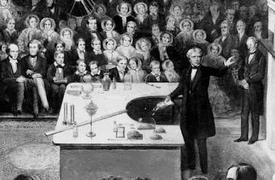
However, getting back to my Mum a story she told was of her Headmaster, one Mr Crickmer who with an interest in local history told the kids in Scarsdale Road school, about the local area, including one story about Michael Faraday. So what is his story and why is a sub station on a South London roundabout a memorial to him?

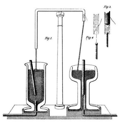
Well Michael Faraday was born nearby in 1791 to a Blacksmith and his wife, but was apprenticed not into that trade, but as a bookbinder. Reading gave him an interest in science and soon he applied to Humphrey Davy (inventor of the Davy Lamp) as an assistant. It was here that he got his scientific education and by 1821 he was experimenting with electromagnetism! Working with Davy and William Hyde Wollaston who had both worked on electrical principles and theory, Faraday, went on to build two devices to produce what he called electromagnetic rotation: a continuous circular motion from the circular magnetic force around a wire and a wire extending into a pool of mercury with a magnet placed inside. This work led eventually both to the Electric Motor and later the dynamo.
Faraday also wrapped two insulated coils of wire around an iron ring, and found that, upon passing a current through one coil, a momentary current was induced in the other coil. This is of course the basis of a transformer, the underlying technology used in power transmission, and therefore in power substations. Faraday's iron ring-coil apparatus is still on display at the Royal Institution.

These brief notes can of course not possibly do justice to this man who was responsible for so much more than just some electrical work, but gives a flavour of why this man's memory is commemorated by of all things a power substation. For more information on Faraday's life click here
http://en.wikipedia.org/wiki/Michael_Faraday


Back at the memorial it is said that when this twenty three metres wide and six metres tall cuboid was built in 1961 nobody really knew what it was. Well 30 odd years later the same was still true as in June 1995, the Evening Standard ran a story with a picture of the box headlined “But what on earth is it?” and this does make me wonder if actually the plan was to save burying the station and it was only later that someone had the wheeze of calling it a memorial.

However I've also read that its architect, Rodney Gordon, intended his design to embody the visionary credentials of our hero. It was originally to be a box of glass which would allow the public to see the transformer which sits within, but fears of vandalism scuppered this idea and with it the clearest link between Faraday’s work and the modern world, so it was that steel replaced glass as the primary construction material.

In 1996 Blue Peter held a competition for children to design a new lighting scheme for the site and in the same year the structure was given grade II listed status. It even has a long dedication in a series if stone plaques set into the ground in front of it – they read ...

“This Stainless Steel Sculpture commemorates MICHAEL FARADAY(1791 – 1867) English Chemist and Physicist Known For His Research Into Electricity and Magnetism Who Lived Locally”

The cuboid's 728 stainless steel panels have stayed very shiny at least from a distance, so it is a survivor and with its listed status will presumably be included into the redevelopment of the site, though, like the Elephant and Castle statue I originally saw in the middle of Shopping Centre, it might get moved around. After all the elephant stood originally on the top of a pub from which the area got its name, and now stands looking at the Metropolitan Tabernacle and has , in it's time been painted bright horrendous pink!

Faraday also moved around of course, and while born locally, died at his Grace and Favour house at Hampton Court on 25 August 1867.

He had previously turned down burial in Westminster Abbey, but he has a memorial plaque there, near Isaac Newton's tomb, but Faraday was actually interred in the dissenters' (non-Anglican) section of Highgate Cemetery.

So next time you're sitting in traffic around the Elephant roundabout spare a thought for the poor blacksmith's son turned good who's work not only helped start you vehicle it also helps light your home.

Laurie Smith

Sunday, 1 June 2008

Nelson and Wellington

What does Trafalgar Square and Nelson’s column commemorate? The easy answer is Nelson’s victory over Napoleon’s forces at Trafalgar in 1805. Or more cynically keeping a German family on the throne and republicanism from these shores.

Napoleon Bonaparte was the scourge of the European monarchies, and the ruling elites of the day were determined to stop him. The Duke of Wellington, with the help of the common soldier and the Prussians, defeated Bonaparte ten years after the Battle of Trafalgar. But what monument is there to Wellington himself? There is a Wellington Arch and Wellington Barracks but they do not feature so prominently in popular consciousness as Trafalgar Square and Nelson’s column.


Wellington Arch sits on the roundabout on Hyde Park Corner (it has been moved a couple of times). But there is no statue of Wellington on top. There used to be but it proved too unpopular.

Between 1803 and 1805 Bonaparte amassed an invasion flotilla of 2,343 ships with the intention of invading Britain. This flotilla was kept in its home ports and prevented from invading by the Royal Navy’s Channel Fleet of 30 plus ships under Admiral Sir William Cornwallis; Nelson played no part in this. It was Cornwallis who put together the fleet that Nelson commanded at Trafalgar.

Nelson was of relatively humble origins. Progress through the ranks of the British Navy was on merit and Nelson became a popular hero and commander. Ashore he was mobbed by crowds as a celebrity would be today. Unfortunately for him but fortunately for his heroic status, he died at the height of his popularity during Trafalgar. Although Trafalgar could not stop Bonaparte it did give Britain naval supremacy. Nelson was no radical but Trafalgar was the cup final in a naval world series that would not be challenged for 100 years or more.

The British merchant and the industrialist http://commons.wikimedia.org/wiki/File:Wellington_Arch.JPG -Attribution: Gt-man were to gain power, wealth and empire from this naval victory. The British army of the time was not so egalitarian. Wellington’s commission was bought for him by his brother. Wellington may have been an effective general but he was no democrat. After his return from Waterloo he became a Tory MP and Prime Minister. After his first Cabinet meeting he is reported as saying “An extraordinary affair. I gave them their orders and they wanted to stay and discuss them.”

He got the nickname the ‘Iron Duke’ not because of military prowess but because of the shutters he had on his house to protect him from the mob. He was booed on the streets for the troops cutting down civilians at a meeting for democracy in Manchester (the Peterloo massacre).


Basically he was an old style aristocrat trying to halt social change. So what does Trafalgar Square commemorate? Not so much a decisive naval victory or the death of a popular hero, more a period of change and the birth of the ‘middle classes.’ And Wellington Arch, a fading era.

John Clark

Thursday, 1 December 2005

Victoria embankment

One of my earliest memories of having, what you might call, a more adult conversation with my father was on a sunny late morning walking along the Victoria Embankment. It would have been the mid 60s and I don’t have a clue where we had been and I can’t even guess why we were walking along the north side of the river between Blackfriars and Westminster when we lived in Peckham but I clearly remember we were and that it was a warm, sunny, halcyon day.

There are some interesting, (well at least I think so), stories to tell based around this area not the least of which is that the place I was walking on that sunny morning so many years ago is a man made construction completed in 1870 to carry both the underground, and the sewers to
clean the river; however I don’t intend to go into that story as we could fill the magazine with it. Suffice to say that if you go into Embankment Gardens beside Villiers Street to can see where the riverside once was from the position of the river gate entrance of the Duke of Buckingham. In doing this 37 acres of new land was reclaimed from the River.

Oddly however there is a much older construction on the “new” riverside than Buckingham's Gate, in fact it is the oldest man-made construction in London. From further back in history, even than the woman for who it is named, Cleopatra’s Needle was originally built and stood in Egypt, around 1500BC. (If you remember Cleopatra was a consult to Julius Caesar who landed in Kent in a mere 55bc).

It was erected on the Victoria Embankment in 1878 following a long sea voyage and the loss of a crew which had been bringing it to London as a “gift” to the British people in recognition of Nelson’s victory over the French fleet, at the Battle of the Nile in 1798. It is made of granite and the obelisk is 68 feet high and 180 tons in weight.

A couple of odd facts about the pink-granite monolith that it stands on a pedestal, supposedly guarded by two sphinxes, I say supposedly ‘cos the Victorian designers got it wrong, in order to guard the Needle they should face out; instead they face in towards it. Under the Needle buried in the pedestal are two earthenware pots, containing various objects. This very early version of a time capsule holds a portrait of Queen Victoria, iron ropes and cables, a hydraulic jack, copies of an engineering magazine, and portraits of 12 of the most beautiful Englishwomen of the time!

Just as Cleopatra’s Needle forms a centrepiece between Waterloo and Hungerford Bridges, (where because of it’s presence the embankment has been given an Egyptian theme with the benches made with sphinxes and camels for arms), another monument also stands on the embankment forming the centrepiece between Hungerford and Westminster.

Completed in 1923 the Royal Air Force Memorial is a simple monument in Portland stone surmounted by a gilded eagle. The original intention was for the eagle to face inwards to the embankment but the design was altered at the last moment so the eagle faced across the river, symbolically to France. The position was not the first choice, discarding a proposal to join the Army and the Navy in building a memorial opposite Buckingham Palace, the Royal Air Force Memorial Fund had hoped to raise a Cross on the ground between Westminster Abbey and St Margaret’s Church; a hope that the Dean of Westminster was unable to approve because he preferred not to consider a memorial for the Royal Air Force alone. So offered a site at the head of the Whitehall Stairs, that’s where the memorial went.

Currently a new monument is being built, the Battle of Britain Monument which is being sited on an existing panelled granite structure 25 metres long. This structure was originally designed as a smoke outlet for underground trains when they were powered by steam engines. It has been filled up and blocked for many years.

A walkway will be cut obliquely through the middle of the structure, and bronze reliefs, depicting aspects of the Battle in the air and the back-up on the ground, will be placed along either side.

I feel this is quite appropriate as both the RAF Memorial and Cleopatra’s Needle were damaged by enemy bombs in the last war, which I remember my father showing me – along with the remains of a pavement artist’s work which had been abandoned there from the day before.

Whenever I walk down the embankment today, especially in the sun, I think of him – not much has changed there since that day. I only wish I knew why we were there – and where we’d been.

Laurie Smith

Sunday, 1 May 2005

The Wandering Obelisk

Situated at the south end of Blackfriars Road, I first became familiar with St George’s Circus when I started work for the South Centre Area of Post Office Telecommunications, the General Manager’s Office of which was situated there in Erlang House. It was also at this time that I first saw the Obelisk standing in the grounds of the Imperial War Museum, not far away, where it had been moved from St George’s Circus in 1905 to make way for a clock tower. The clock tower too, however, had long vacated the circus by the time I was travelling through the junction, leaving a bland traffic island.

The Obelisk had been erected at St George’s Circus in 1771 following the construction of Blackfriars Bridge and approach road in the 1760s. The Blackfriars Bridge committee had ordered that, “an Obelisk should be placed in the middle of the circus at the road junction in the fields”.

The area, once known as St George’s Fields was naturally swampy ground and had been used mainly for pasture, and cloth dyeing and bleaching. This can be seen on old maps of the area, which show the “Tenter Grounds” as taking up huge areas around what is now Blackfriars Road. (Tenter grounds were where the tenters stood, frames upon which cloth was stretched and dried after treatment. Attached by means of Tenter Hooks – which we have all, proverbially, been on from time to time)

Some sources say that the Obelisk was put up in the Mayoralty of Brass Crosby to his honour, though I have found no original source which states this. The inscription on the obelisk only says who was King and Lord Mayor, which was certainly Crosby, at the time.

However it is interesting to relate Brass Crosby’s claims to fame, as prior to researching this article I, for one, was unaware of who he was, yet he was instrumental in improving our civil liberties.

Born in Stockton-on Tees in 1725 he qualified in law and came to London to practice. He was elected to the City Council in 1758 and then held the offices of Sheriff, Alderman and MP until, in 1770, he was elected Lord Mayor of London. As Chief Magistrate one of his first acts was to refuse the issuing of warrants for press gangs, and subsequently ordered constables to prevent the seizure of men.

His biggest battle however was with the House of Commons, when in 1771 he released a printer who was brought before him for daring to publish reports of Parliamentary proceedings. Crosby was subsequently ordered to appear before the House to explain his actions and was committed to the Tower of London. Following several public rallies in support of his stand however, Crosby was released six weeks later. A jubilant procession accompanied him from the Tower to the Mansion House. It is from this event that we got the phrase “Bold as Brass” to mean somebody who is forthright and stands up for themselves. No further attempts have ever been made to prevent the publication of Parliamentary debates.

Brass retired to Chelsfield in Kent where he lived until he death in 1793, today a Blue Plaque marks where he lived, though that is little more revealing than the inscription on our Obelisk.

Milestone or Memorial today the Obelisk stands again in St George's Circus, where it was returned in 1998 having been cleaned up and repaired. Disregarded by many on their way to work it is older than anything around it, and acts as a reminder of our history.

Laurie Smith

Tuesday, 1 February 2005

The Big Wheel

In writing this series I have up to now, had some connection or personal interest in the subject prior to deciding to write the article but with this one it was finding a picture that intrigued me. Though I have worked in and around Earls Court at various odd times in my career, my earliest visits were at the beginning in 1975 when I had to get off at Earls Court tube station and exit the Warwick Road end in order to walk up to Charles House, where the Post Office then had a training school.

As you leave the station the Earls Court exhibition centre opposite is quite a sight. As a working class south London lad this was my first sight of the famous exhibition centre. The land it occupies was once an awkward triangle of railway tracks, sidings and depots owned by the Earl of Zetland from who it gets its name. Opened in September 1937, the exhibition centre cost £1.5m and was designed by Chicago architect, C Howard. At the time it was the largest reinforced concrete structure in existence.

Exhibitions on the site predate the building however and if I had been there at the turn of the last century I probably would have been even more impressed with the view of the area, as I would have seen the “Gigantic wheel”. Originally built as part of the Empire of India Exhibition in 1895, it stayed there 11 years.

Looking reminiscent of the “London Eye” on the South Bank, the “Gigantic wheel” was also an observation wheel, one of a series of such wheels, the first of which was the “Ferris wheel” at the Chicago Exhibition of 1893. It was this wheel which gives all such “big wheels” their America name and provides another, earlier, connection for the Earls Court site to Chicago. The name came from its designer, George Washington Gale Ferris, whose idea was for an “observation wheel 250 feet high”.

Construction work began on the larger Earls Court wheel in March 1894 when massive concrete footings were put in and it was opened to passengers in July 1895. It had a diameter of 300ft, (larger than the original American one), weighed 1,100 tons and completed one revolution in about 25 minutes. Originally there were to be ‘recreation towers’ on either side with lifts carrying visitors up to the axle, through which it would have been possible to walk, but this was not carried through. The wheel was rotated by means of two 50HP steam engines. Each of the forty cars could accommodate forty passengers so that up to 1,600 could ride the on the wheel together, when it was said that from the top you could see Windsor Castle.

In 1896 another wheel was opened in Blackpool. That big wheel was 214 feet high, and rotated every 15 minutes compared with the 25 minutes of its London rival. It was not tremendously successful however, perhaps because the tower at 519 feet, over twice the wheel’s height, overshadowed it, and it closed relatively quickly.

The final one was built in Vienna; that wheel lasted ‘til it was bombed during the war but it was rebuilt after the war and still exists today. You may remember it in films like “The Third Man” and “The Living Daylights”

Our Earls Court “Gigantic Wheel” suffered an embarrassment in May 1896 when it got stuck for four and half hours. The passengers were handsomely compensated for their ordeal though and this increased its popularity for a while as people hoped they could get a ride and make a profit into the bargain. It was reported that the following day there was a queue of approximately 11,000 people all hoping to get stuck in the wheel and claim their five pounds compensation! Despite this the Earls Court “Gigantic wheel” survived until 1906 when it was demolished because it was no longer profitable. In its life it had conveyed two and a half million passengers.

It was said that it was “a pity that all the ability and cost expended in its construction should not have been devoted to some more useful end than carrying coach loads of fools round a vertical circle’’.

However in spite of such views, (and if you pardon the pun), if it had been in a more central location then, judging by the London Eye, perhaps it would still have been here today. I’ll never look at the London Eye or Earls court in quite the same way again.

Laurie Smith

Wednesday, 1 December 2004

In and out The Eagle

Laurie thanks for reviving the memory – sticky fingers. I am referring of course to cakes and your last article and the Lyons Tea House at the Angel. Lots of sticky cakes, when I was a child my father was chef at Lyons at the Angel, and Gran lived round the corner but that’s incidental.


The Angel stands at one end of the City Road the other end is at Old Street, just round the corner from where I did my early training courses with Post Office Telecoms at Paul Street, a massive, then modern institution clad in glass and steel. One oddity I remember was that erected in the basement were short telegraph poles for the “Over Head” courses. Opposite the training school was another massive building, this time Victorian, from the architectural school of dark satanic mills, occupied by the firm of Blades and Blades East, a printing firm where Grandfather once worked, but that’s incidental. All have now gone and are just a memory.


The area is rich in history much beyond memory, in the 17th century the Fortune Theatre and the Red Lion Theatre provided theatre goers with entertainment outside the control of the City of London. The 1680s saw the new fad of drinking spring water. One of the springs was at Thomas Sadler’s music house. My mother and her sisters remember playing on this derelict site as children. They had no knowledge of the history of the their play ground until the well was rediscovered during redevelopment of the site, which is now occupied by Sadler’s Wells Theatre.


For the less discerning there was Stokes’s Amphitheatre offering bull and bear baiting, sword fighting and women’s wrestling. The New Red Lion offered cock-fighting. Slowly, however, the authorities exerted control and the area began to become gentrified, as can still be seen in the existing Georgian streets and squares, though the grim grip of London was not far away. In the 1740s the area had London’s first smallpox hospital before it moved further out of London, in 1794, to sunnier climes; the current site of King’s Cross Station. Then came industrialization, the Regents Canal and the Railways, followed by poor housing, slums and growing poverty. The local vestries, predecessors to the Borough Councils, were reluctant to use their enforcement powers against the slums, as often they were the landlords. Conditions were chronic and required political solutions – the formation of the borough councils and the London County Council.


The Regent’s Canal is still a notable feature of the area although much quieter than it once was. Once one of its great basins cut across the City Road, no doubt full of water borne traffic. Which recalls another memory associated with the City Road – the children’s poem:


Up and down the City Road,
in and out the Eagle.
That’s the way the money goes,
pop goes the weasel.


I can certainly remember a pub in the City Road named the Eagle, perhaps it’s still there, perhaps it’s the one referred to in the poem. I don’t know for sure, but the story is that, at one time the Landlord of the Eagle ran a pawn brokers business on the side. Those short of money would go to the pub to pawn their possessions and no doubt drink the proceeds. The weasel was an iron. Well that’s the way the story goes, according to my memory. Is it memory, an oral tradition handed down through generations as a cautionary tale against exacerbating poverty, or is it history – what do you reckon?

John Clark
